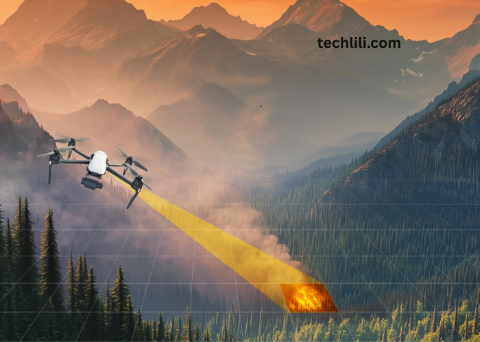
Wildfires pose serious threats to lives, property and ecosystems, requiring rapid, informed response from emergency teams. To meet these challenges, drones have emerged as essential tools for real-time assessment, fire mapping and resource coordination. Unlike traditional aircraft or ground crews, drones can safely access active fire zones, offering fast and flexible support for firefighting operations. Sonoran Desert Institute (SDI), accredited by the Distance Education Accrediting Commission (DEAC), trains students in drone technology applications relevant to emergency response. Notably, Sonoran Desert Institute reviews often highlight the school’s practical, career-focused training that prepares graduates to support mission-critical operations, like wildfire assessment, with confidence and skill.
Unlike traditional aircraft or ground crews, drones offer flexible, safe access to active fire zones. Equipped with high-resolution cameras, thermal sensors and mapping technology, drones collect critical data that allows incident commanders to make informed decisions, while minimizing risk to personnel.
Real Time Fire Perimeter Mapping
One of the primary uses of drones in wildfire response is mapping the fire’s perimeter. As fires spread, understanding their boundaries helps responders prioritize containment efforts and protect threatened areas.
Drones fly over active fire lines and capture high-resolution images that are processed into real-time maps. These maps give commanders a clear view of the fire’s size, shape and direction of movement, allowing for rapid adjustments to containment strategies.
Thermal Imaging for Hot Spot Detection
Thermal sensors mounted on drones detect heat signatures that are not always visible to the naked eye. These sensors identify hot spots, flare-ups and areas of continued combustion, even through smoke or at night.
By locating hot spots quickly, firefighters can direct suppression efforts where they are most needed, preventing reignition and limiting fire spread. Thermal imaging also helps assess the effectiveness of containment lines and monitor fire behavior as conditions change.
Assessing Terrain and Accessibility
Wildfires often occur in remote or rugged terrain that is difficult for ground crews to access safely. Drones provide aerial views of slopes, canyons, and dense forests, helping planners evaluate access routes and potential hazards.
This terrain data supports the safe positioning of fire crews, equipment and evacuation routes. By identifying obstacles early, commanders improve operational planning, while reducing risks to responders.
Monitoring Weather Conditions and Wind Patterns
Weather conditions play a major role in wildfire behavior. Wind speed, direction, humidity and temperature influence how quickly fires spread and how suppression efforts proceed.
Drones equipped with environmental sensors monitor localized weather conditions across the fire zone. This information allows meteorologists and fire behavior analysts to predict shifts in fire activity and advise commanders on potential risks.
Supporting Evacuation Planning and Public Safety
Accurate situational awareness is essential for protecting communities threatened by advancing wildfires. Drones provide live video feeds that allow emergency managers to monitor fire proximity to homes, businesses and critical infrastructure.
This information supports evacuation orders, road closures and public safety announcements. Early detection of shifting fire lines gives residents more time to evacuate and allows emergency services to coordinate traffic flow and shelter availability.
Guiding Aerial and Ground Suppression Efforts
Firefighting aircraft drop water and fire retardant along containment lines to slow fire spread. Drones assist these operations by scouting drop zones, verifying target accuracy and assessing the impact of each aerial pass.
Ground crews also rely on drone data to guide suppression tactics, monitor progress and ensure containment lines remain intact. Real-time feedback improves coordination between air and ground teams, increasing the effectiveness of firefighting efforts.
Assessing Damage and Recovery Needs
Once a wildfire is under control, drones play an important role in assessing the damage and helping plan the road to recovery. Aerial surveys capture detailed views of burned areas, damaged infrastructure, and environmental impact.
This information can be used to support insurance claims, apply for government aid, and guide habitat restoration efforts. The high-resolution imagery also helps recovery teams figure out where to focus repairs, spot dangerous debris, and make smart decisions about how to allocate resources.
Minimizing Risk to Personnel
One of the greatest advantages of drones in wildfire response is reducing the need for human exposure to dangerous conditions. Drones collect data in active fire zones, without placing pilots or ground crews at risk.
By monitoring fire behavior remotely, incident commanders maintain a comprehensive view of the situation, while protecting firefighter safety. Reduced reliance on traditional aircraft also minimizes exposure to hazardous smoke, unpredictable winds and flying embers.
Enhancing Nighttime Operations
Wildfires continue to burn around the clock, but nighttime operations present visibility challenges for both air and ground teams. Drones equipped with thermal sensors excel in low-light conditions, providing continuous monitoring throughout the night.
Nighttime drone surveillance supports containment efforts, tracks fire progression and identifies new ignitions that might otherwise go undetected until morning. This early detection allows crews to respond quickly and limit fire expansion overnight.
Supporting Interagency Collaboration
Wildfire response often involves multiple agencies, including federal, state, and local fire departments, emergency management offices and law enforcement. Drones provide shared situational awareness across agencies by supplying real-time imagery and data.
Common data platforms allow all responders to access consistent information, improving coordination and resource deployment. This unified approach strengthens operational efficiency during complex, multi-agency wildfire incidents.
Training Professionals in Drone Operations for Wildfire Response
Effective drone deployment in wildfire response requires skilled operators who understand both technical flight procedures and emergency management protocols. Sonoran Desert Institute provides education in drone technology, covering areas such as flight planning and sensor integration, which are valuable in emergency operations like wildfire response.
Students learn flight planning, sensor integration, data processing and safety considerations for wildfire missions. These skills prepare graduates to assist firefighting agencies, emergency management organizations and public safety teams during wildfire events.
Investing in Technology for Future Wildfire Preparedness
As wildfires increase in frequency and intensity, investments in drone technology, data infrastructure and professional training will continue to strengthen response capabilities. Advances in sensor technology, AI-powered analysis and communication networks further enhance drone effectiveness during emergencies.
Ongoing research and interagency collaboration ensure that drone-based wildfire response develops to meet emerging challenges, improving both prevention and suppression efforts.
Drones have become essential tools in modern wildfire response. They provide rapid situational assessment that supports effective firefighting, evacuation planning and recovery operations. By offering real-time data and minimizing risks to personnel, drones strengthen overall emergency preparedness.
Through professional education, technical training and industry partnerships, institutions like Sonoran Desert Institute provide students with the knowledge and skills necessary to support drone-based wildfire response. As wildfire threats continue to grow, well-trained professionals play a critical role in helping emergency teams protect communities and manage natural disasters.